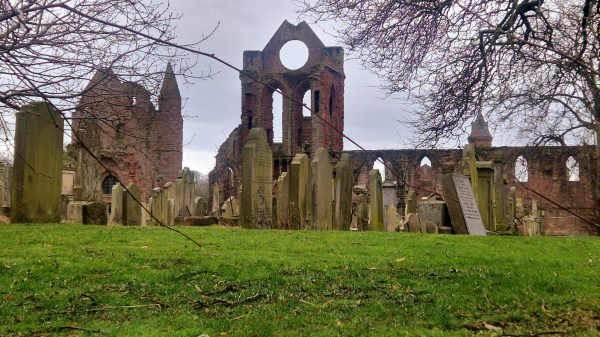
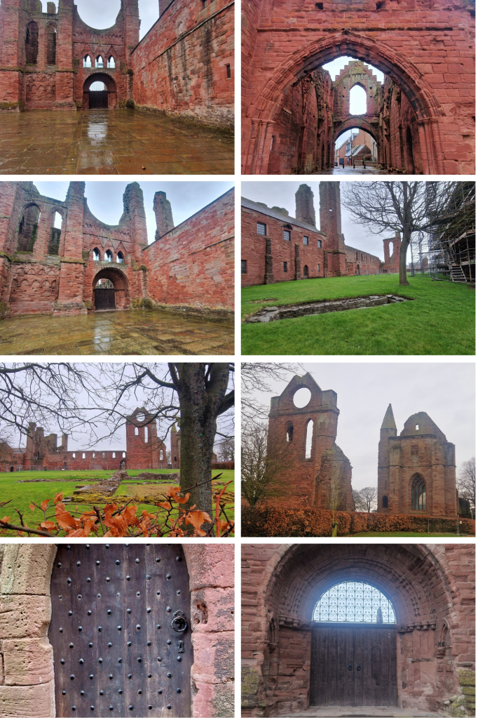
As you walk into the heart of the city of Arbroath, you get a feeling of the enormity that this Abbey once was. Impressive parts of this red sandstone cruciform Church still survive, the west end, south transept & sacristy, the gatehouse and the Abbot’s house which is now the museum. The cloister and other buildings are now ruinous but their foundations are still apparent and there’s also a large cemetery within the grounds.
Arbroath Abbey was founded in 1178 by King William (1st), the Lion, for the Tironensian Benedictin Monks from Kelso Abbey. King William bestowed considerable lands and great wealth upon the Abbey as well as custody of the Monymusk Reliquary, the casket believed to contain the relics of St Columba. It’s believed that he had the Abbey built in memory of his murdered dear friend, Thomas Becket (St Thomas the Martyr) and in the hope of currying favour with God for his own safety. William had been captured by English forces at the Battle of Alnwick in 1174 and only released by King Henry II a year later after being forced into signing the Treaty of Falaise which acknowledged Henry as William’s feudal superior. William was eventually buried here in 1214.
The Declaration of Arbroath, asserting Scottish independence over English aggression, was signed here in 1320. The original document is in the keeping of National Records of Scotland however a copy can been seen in the abbey’s museum. In 1951 a group of students stole back Scotland’s Stone of Destiny from Westminster Abbey. It had been seized in 1296 by Edward I of England from Scone Palace (nr Perth) where all Scottish Kings were crowned upon it. Edward took the stone to demonstrate his power over Scotland. It was used in the coronation of British monarchs thereafter however this was hugely resented by Scots. The students eventually placed it at the High Alter of Arbroath Abbey. The Stone of Destiny is now currently on display at Perth Museum.
In the 1800’s Arbroath’s huge fishing fleet would look for the massive round window of the Abbey’s south transept gable to guide them home from the open sea. A red beacon fire was lit at the iconic window and this practice gave the people from Arbroath the nickname of ‘Red Lichties’ (red lights).
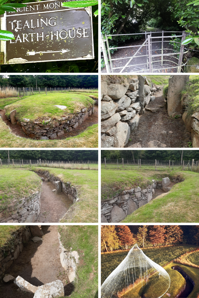
It’s amazing the things you come across by chance. I was driving north to Aberdeen when I noticed the signpost for this place, so intrigued, I stopped by to check it out….and what a fantastic find!
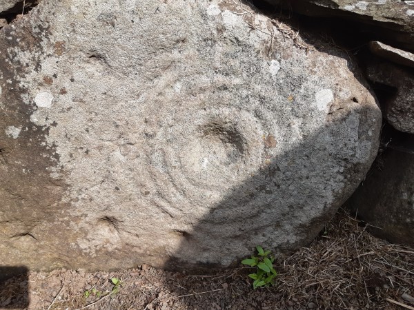
This isn’t actually an ‘earth house’ but an Iron-Age souterrain, a subterranean passage that was originally roofed over with stone slabs. A small room at the end of the chamber here had been created by a pair of huge, up-right slabs. It was discovered in 1871 while a local farmer was ploughing the field here. Souterrains can be found around Scotland’s eastern coast and built around 2,500 years ago, they would have been part of farming settlements made up of clusters of timber roundhouses. Souterrains seem to have been accessed from within a roundhouse built above, providing a cool dark place, most probably used for storing food. They would, however, have been vulnerable to dampness and vermin. They could also have been used as places of refuge if the settlement was under attack. As you can see from the stone-walling, this was skilfully built and may have incorporated a symbolic function. Here at Tealing, pre-historic rock art is carved into one of the huge stones by its entrance. The cup and ring marked stone perhaps represents the sun, the portal to a spirit world, even life itself, or life beyond this realm – eternity.
Excavation at Tealing found animal bones, shards of pottery, broken grinding stones for wheat and fragments of Roman glassware, the latter, suggesting trade routes with distant places. It could also mean this souterrain might still have been in use when the Romans passed through here. Only a few miles East of Tealing a further two Souterrains can be found – Ardestie & Carlungie while another, Culsh Earth House can be found near Tarland in Aberdeenshire.
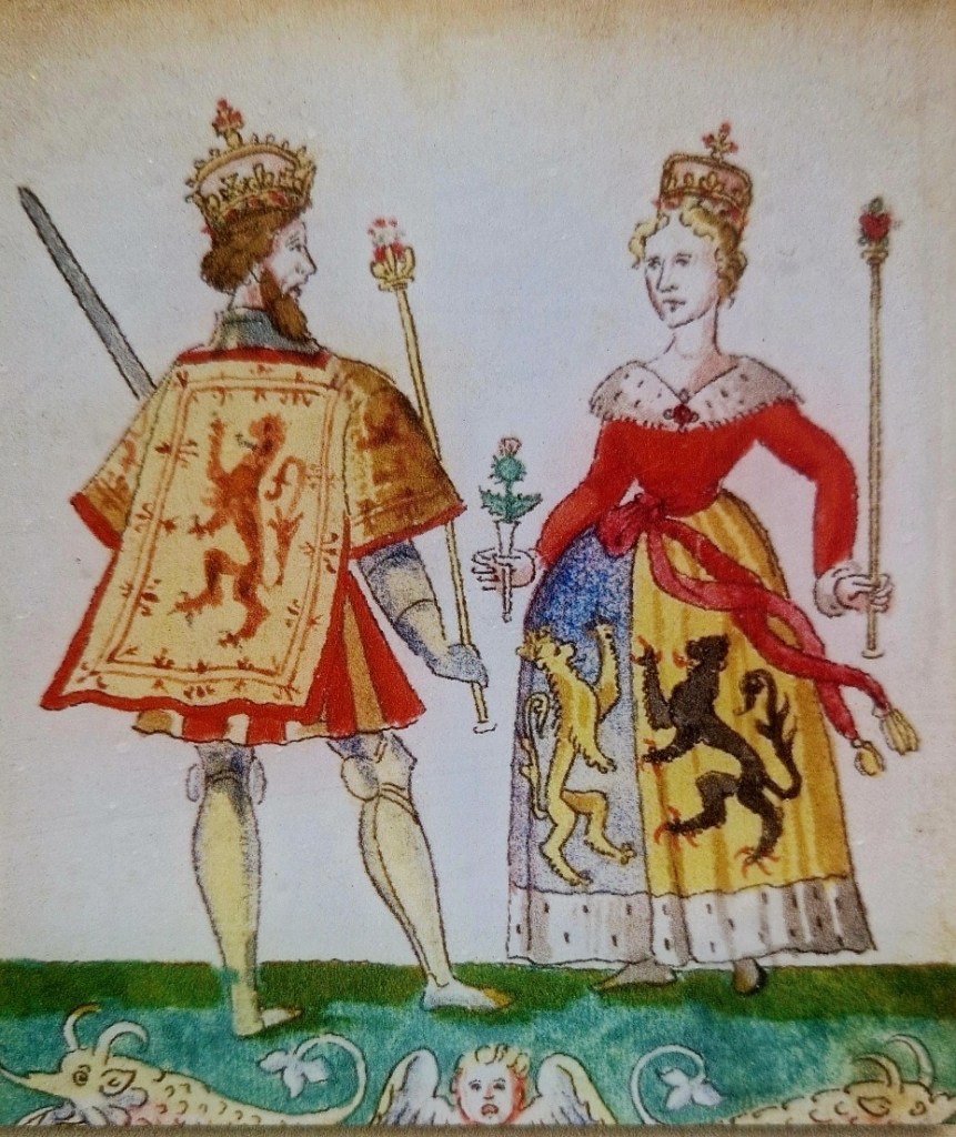
Now ruinous, Ravenscraig Castle belonged to one of the most powerful women in Scottish history, Queen Mary of Guelders, wife of James II. Mary was descended from one of Europe’s most prominent families and had been raised at the court of her great-uncle, The Duke of Burgundy. She arrived in Scotland in June 1449, first visiting the Isle of May to pray at the shrine of St Adrian before making her way to Leith and staying at the Convent of St Anthony. On her wedding day, on 3 July 1449, crowds of commoners and nobles lined the streets of Edinburgh to watch her make her way to Holyrood Abbey for her marriage to King James II of Scotland. She was 14 and he was 18.
In 1460 King James gave his wife the land here at Dysart to build a castle but he was killed just a few months later. James had witness the introduction of gunpowder and was fascinated with artillery so the Duke Of Burgundy gifted him Mons Meg (this still sits on the parapet of Edinburgh Castle to this day). Mons Meg is a massive, iron cannon which took a team of oxen to move, constantly became stuck because of its enormous weight and could travel no farther than 5km a day. As Roxburgh Castle had long been held by the English, King James ordered some special new cannons from Flanders to ensure success in his bid to retrieve Roxburgh. During the siege, he stood proudly beside one of his new cannons, The Lion, and ordered it to be fired. One of the cannons iron rings had worked loose during transportation and it exploded, sending a piece of iron slicing through the King’s thigh, cutting it in half. He bled out quickly and was dead within minutes. King James was 29 years old. Roxburgh castle fell to James’ forces a few days later.
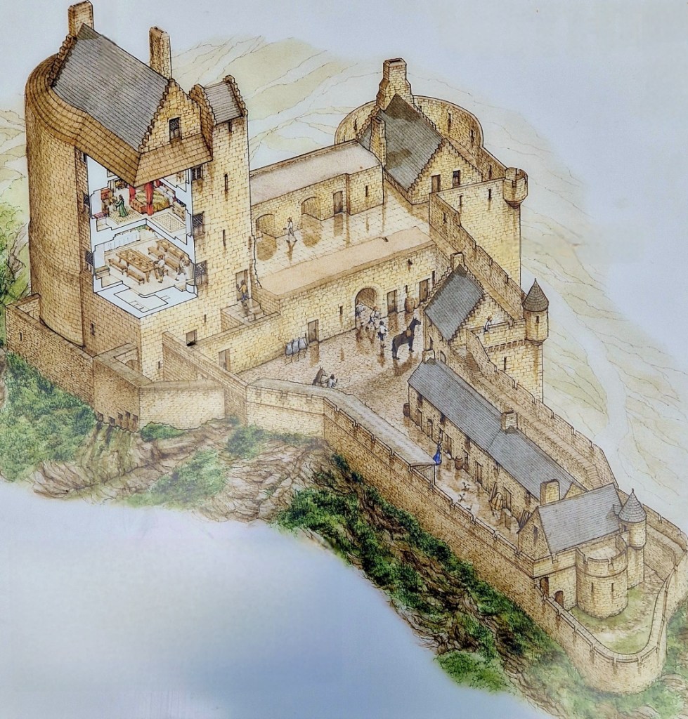
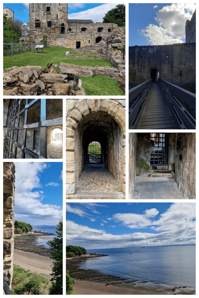
The death of King James left Mary to rule over the Kingdom as regent, on behalf of their young son James III. She was only in her mid-twenties when she took over governance of Scotland and ordered the construction of Ravenscraig Castle. Ravenscraig was built as a fortress to guard the Firth of Forth and the first in Scotland erected to withstand return artillery fire. The Castle consists of two D-plan towers with 3.5m thick walls, linked by a two-storey block with a broad parapet and gun loops for safely firing upon attackers. The courtyard is cut off from the surrounding area by a very deep ditch and could be reached only by drawbridge. Building this Castle was a huge undertaking and the Queen employed master of works, David Boys, to lead a team that included master carpenter, Andrew Lesouris, and master mason Henry Merlzioun. Between 1461 & 1462 more than £600 had been spent. The construction, however, was interrupted when Mary died at Ravenscraig, just three years after her husband in 1463.
King James III wasn’t interested in Ravenscraig so made William Sinclair, who at the time was 1st Earl of Caithness and Norse Earl of Orkney, exchange his fiefdom of Kirkwall Castle on Orkney for Ravenscraig Castle in Dysart in 1470. At that time, only three storeys of the east tower and the foundations of the adjacent hall were complete. Sinclair continued the building, altering the original design and had a gun platform constructed where Queen Mary’s great hall had been planned. It was to be a self contained residence with a bedroom on the top floor, the great hall below, then public areas, a bakery and other outbuildings filled the promontory. The gun platform was located between the two towers with cellars underneath. Ravenscraig Castle is known to have protected Merchant Ships from pirates who were based on the Isle of May in the outer part of the Forth Estuary.
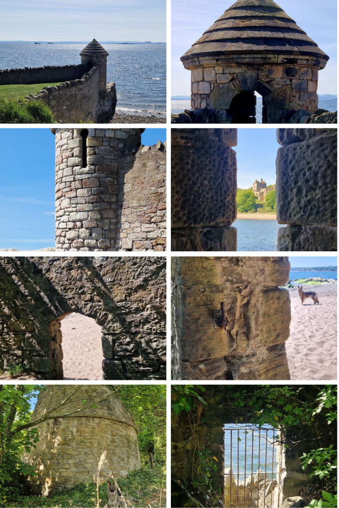
Built eastward along the shore from Ravenscraig, high walls protected against would-be invaders. A watchtower is built into the wall from which guards would have seen vessels coming & going from all directions. A gateway through the wall would have allowed for the delivery of goods, although this originally had a secure iron gate. A beehive dovecot from the 16th century also remains. The pigeons housed within would have been an important source of meat and eggs during tough winter months. The land around the castle is now parkland, ‘Ravenscraig Park’, once known as ‘Three Trees Park’. Legend tells that three brothers of the Sinclair family mistook each other as robbers one dark night and shot each other dead. Trees were planted over their graves.
Ravenscraig Castle remained in the Sinclair family until 1898 when it was sold to local linoleum manufacturer, Sir Michael Nairn, then finally taken into State care in 1955 due to its decayed and dangerous condition. Some parts of the Castle are still accessible to visitors but, disappointingly, the stairway to the remaining upper level is now locked behind an iron gate. Millie & I scrambled around trying to take photos but they don’t do justice to the size and might of this once proud Castle, built here in this prominent position overlooking the Firth of Forth.
NB: Notably, William Sinclair also had Rosslyn Chapel built.
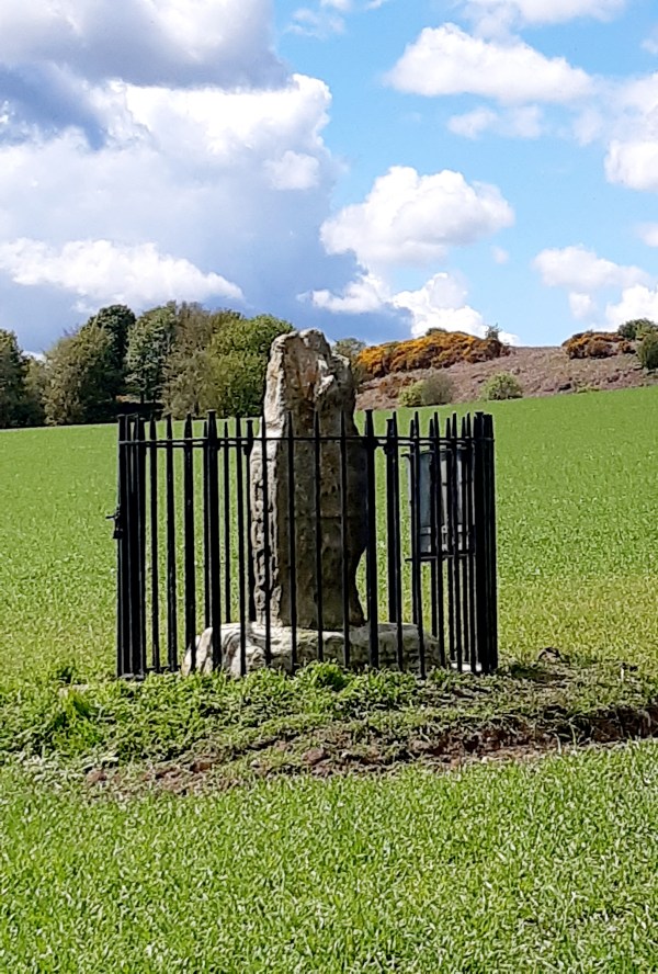
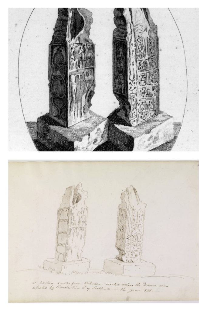
In a wheat field at Dogton Farm, there stands a long forgotten Pictish Stone. Enclosed in iron fencing for protection, it’s a 9th century Class III, free-standing Pictish Cross which seems to have lost its head and arms centuries ago. An etching of the stone was done in 1772 by Thomas Pennant (1726-1798, Welsh naturalist, traveller, writer & antiquarian). Then, another sketch from 1832 by James Skene (1775-1864, Scottish lawyer and amateur artist, best known as a close friend of Sir Walter Scott), mentions that the stone was “at Dogton, 4 miles from Kirkcaldy, erected where the Danes were defeated by Constantine 2 of Scotland in the year 874”. Both illustrate the Dogton stone in its damaged condition.
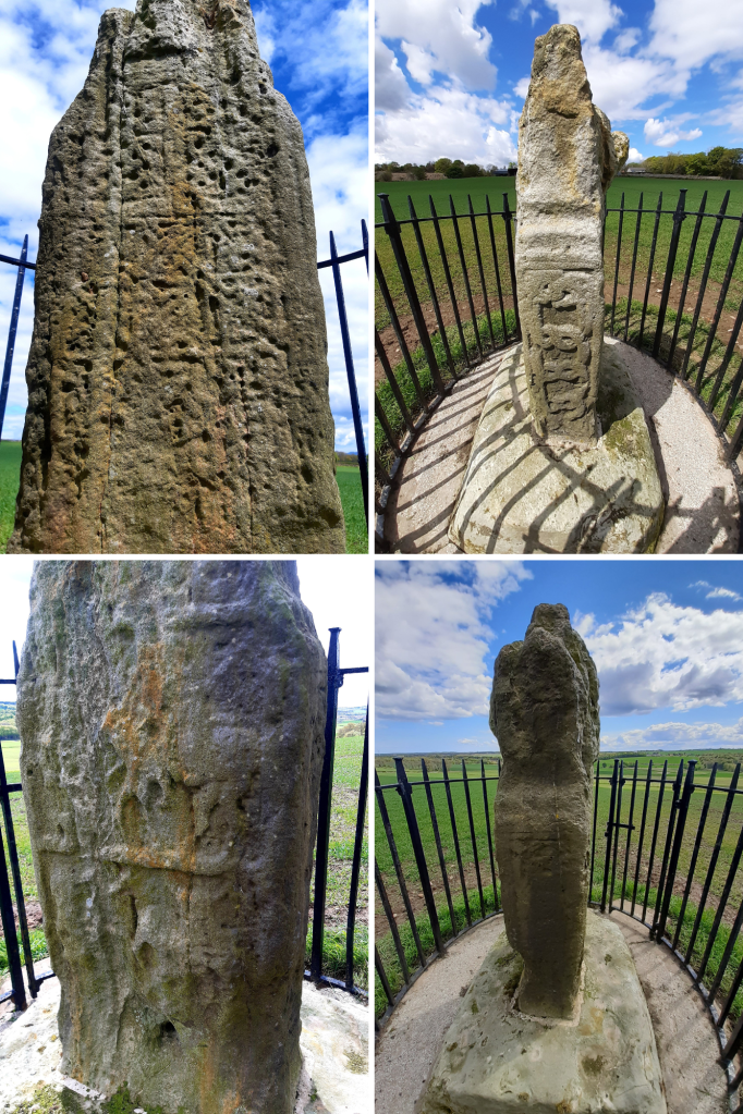
The stone stands around 4ft 10ins (1.5M) and had originally been sculpted in relief on all four sides, however, the weather over these many centuries has taken its toll. On the West facing side, intricate knotwork, typical of Celtic artistry can still be clearly seen. Stretching up the South side of the stone, two entwined, snapping serpents are depicted. It’s said that in Celtic culture, serpents were sacred to high-ranking members of society, associated with rebirth, eternal life and healing. The East face shows what once was a battle scene, with a horseman still quite visible. Unfortunately the North face of the Dogton stone is so very weathered, it’s not longer discernible.
What an incredible sense of awe I felt, to have come across such a remarkable piece of ancient history and it set my mind rambling with thoughts of the people who created this and why it would have been erected here. It’s possible the stone could have been erected to specifically mark the victory in battle of Constantine 2nd over the Danes, or, perhaps, simply as a decorative way marker for pilgrims heading towards religious sites such as nearby Scotlandwell, Lindores Abbey, Balmerino Abbey, or St Andrews where holy relics of Saint Andrew were displayed in the Cathedral there. Oh to be a time traveller….
NB: Class III Pictish Stones – these originate from the 8th or 9th century and feature none of the unique Pitctish symbols of earlier stones, typically free-standing crosses which include Christian imagery.