The Eleanor Cross – Kenmore, Perthshire

I’d parked overnight in a layby at the east end of Loch Tay at Kenmore and took a swim in the morning sunshine alongside several other morning dippers. Slipping into the cool, clear water of the still loch was a refreshing way to wash away the remnants of sleep. Meanwhile, Millie danced around at the waters’ edge desperate for me to come out. She’s a paddler not a swimmer.

I’d brought my Children camping to Kenmore over the years so it evoked happy memories to be visiting again. There are lovely walks around this area and so Millie and I set off on a jaunt through the woods to take in the Eleanor Cross and onward towards Aberfeldy. The pathway starts by the bridge at the mouth of the Loch and meanders along the north side of the river for a while then heads up the hill through the woods. The Cross was commissioned in 1831 by Lord Breadalbane in tribute to his beloved wife Mary. At that time it would have had a view of the hills and down along the valley with beautiful vistas of the River & Loch Tay. In all these many years however the woodland has grown up high into beautiful mature trees with birdsong echoing through them.

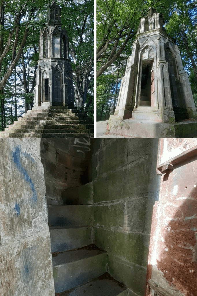
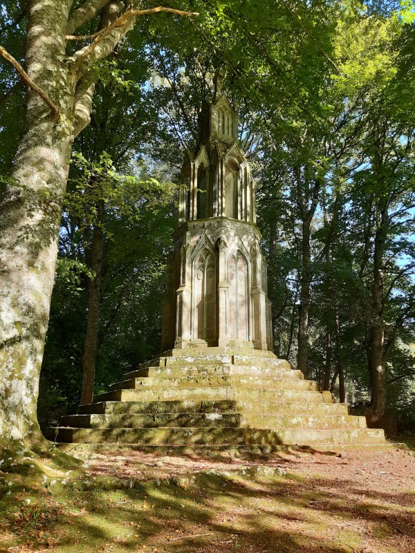
Eleanor Cross is built on the site of an old summer house known as Maxwell’s House. It stands 30 feet tall with a 9 step octagonal base encircling it, a cruciform mid section and a square pinnacle top surmounted with a cross. Delightfully, a door on its south side opens to a spiral stairway. This leads to a small open-air arched gallery surrounding the structure. Climbing up the steps, it feels like a childhood adventure to reach the platform and look through the trees at height. Sadly the interior has been sprayed with graffiti: evidence of bored minds and idle hands.

A brass plaque acclaims – This Building is Dedicated to my Faithful Friend and Fellow-Labourer, MARY, COUNTESS OF BREADALBANE, whose maternal care has been extended to all around this place. anno domini, 1831.

I’ve been as yet unable to ascertain why this particular monument was named ‘Eleanor Cross’ so for the moment will surmise that the reason was purely a romantic gesture in keeping with Breadalbane’s status and the era. (The Victorians were fond of building ornamental ‘follies’ and they can be found throughout Scotland in beautiful rural settings.) NB: King Edward I of England had twelve Eleanor Crosses erected as markers built along the funeral route taken by his wife Queen Eleanor of Castile. They marked the nightly resting places of her coffin procession from Lincoln to Westminster Abbey in 1290.

Tomnaverie Stone Circle, Tarland – Aberdeenshire

I happened upon this stone circle when I’d come to find nearby Culsh Earth House. Thought to have been built around 5,000 years ago, this is one of several stone circles unique to the north-east of Scotland as it has a recumbent stone. Framed by the recumbent stone the stones flanking either side, the focus of this circle seems to have been Lochnagar, the prominent mountain 20 miles(32km) south-west of here. The Neolithic people who built this circle would have used it to mark the movement of the Moon throughout the year. They undoubtedly linked the landscape and the stars with their spiritual life and would have revered this site as a place of worship. Set upon this wee hill at the centre of these flatlands known as ‘the Howe’, it’s likely that other communities and their stone circles would also have been visible from here.

The centre of this particular circle, surrounded by kerb stones, is known to have been used for cremation pyres. A mound of charcoal, burnt soil and bone was excavated from the centre here in the 1990’s.

Little Garve Bridge, Garve – Ross & Cromarty

In the wake of the 1715 Jacobite Rebellion, General George Wade oversaw the building of a massive road infrastructure to support the movement of the British Army in the Highlands for the purpose of maintaining suppression of the population. A network of over 250 miles of interconnecting roads and 40 bridges were built, predominantly determined by the location of forts and army barracks. There are areas of the road and some bridges still in use today and referred to these days as the ‘Old Military Road’.

Now a scheduled monument, Little Garve Bridge spans a deep chasm of the Black Water River and had been part of the military road between Contin & Poolewe on the West Coast. Although known as Wade’s Bridge, it was in fact commissioned by his successor, Major William Caulfield.

Balfarg Henge & Balbirnie Stone Circle, Fife

Located on the outskirts of Glenrothes in Fife, Balfarg Henge is now incongruously surrounded by a modern housing estate. Encircled by hills, this was once a revered landscape and main centre of ritual, sacred to generations of prehistoric people. While there are only two of its original stones remaining and sadly, a rather underwhelming place to visit these days than other Neolithic monuments in Scotland, (such as Calanais in Lewis or Ring of Brogdar in Orkney) 4,000 years ago Balfarg Henge would have been equally as evocative.  The ceremonial, circular enclosure, measuring 60 metres across (known as a ‘henge’), was formed by a bank with an internal ditch and encompassed temples for the living and graves for the dead.  Evidence of ritual feasting, sacrifice, smashed pottery and human burial were found here and at the centre of the henge, lying level with the grass, is a massive stone slab which covers a stone cist, containing the remains of a teenage boy from that period.

The nearby Balbirnie Stone Circle was excavated then moved when the current main road was widened.  It originally had been only 300 metres from Balfarg Henge, in a much more prominent position with the circle facing the midsummer sun rising over Clatto Hill.  It had a hearth at its centre, perhaps for lighting up night-time ceremonies. Communities would have gathered here to celebrate seasonal festivals and to honour their ancestors. Balbirnie became a place of burial where the cremated bones of women and children were placed in stone cists, along with precious objects.

Neolithic peoples cleared woodland and introduced agriculture to Fife around 6,000 years ago.  They were also hunter-gatherers, moving from place to place throughout the year as seasons changed. The efforts made by these people to build shared sacred sites like Balfarg and Balbirnie affirms that their society was sophisticated and organised.

Queen’s Well, Glen Esk

A 4mile (6.4Km) roundtrip ‘stroll’ will take you from Invermark to the magnificent ‘Queen’s Well’ in Glen Esk. The route is strewn with boulders so presents a bit of a challenge in places, however, certainly worth the effort as the scenery is spectacular, especially when the heather is in full bloom.

This granite crown shaped monument sits over a natural spring originally known as the ‘White Well’. The stone well was erected by Lord Dalhousie in 1861 to commemorate a visit made there by Queen Victoria and Prince Albert earlier that year. During their annual sojourn at Balmoral, the Royal couple and their entourage rode the 15mile (24Km) trip on ponies from Bridge of Muik, stopping for a picnic along the way. They met with Lord Dalhousie at the White Well where they refreshed themselves with the spring water before heading off to spend the night at his home, Invermark Lodge.

The inscription at the monument reads – ‘Her Majesty, Queen Victoria, and his Royal Highness the Prince Consort, visited this well and drank of its refreshing waters, on the 20th September, 1861, the year of Her Majesty’s great sorrow.’

Albert died on 14th December 1861, aged 42 years, having been diagnosed with typhoid fever.

Blog at WordPress.com.

Up ↑