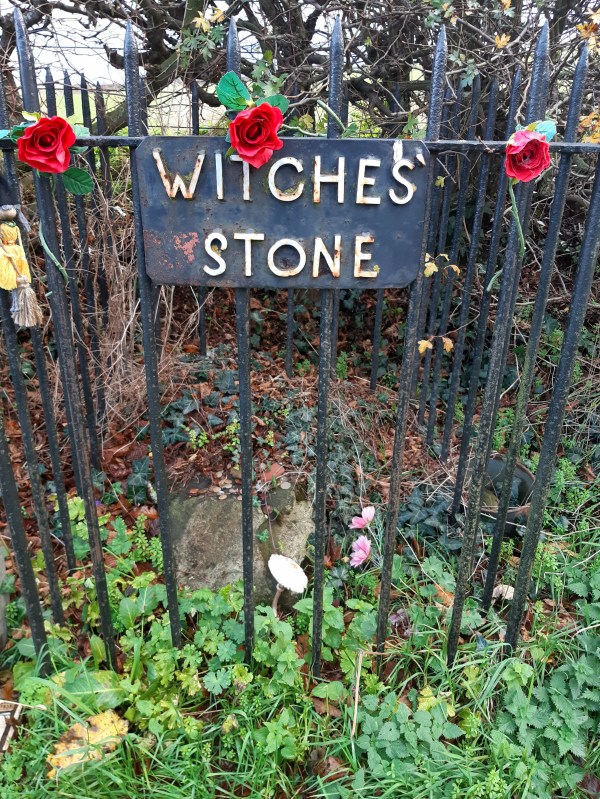
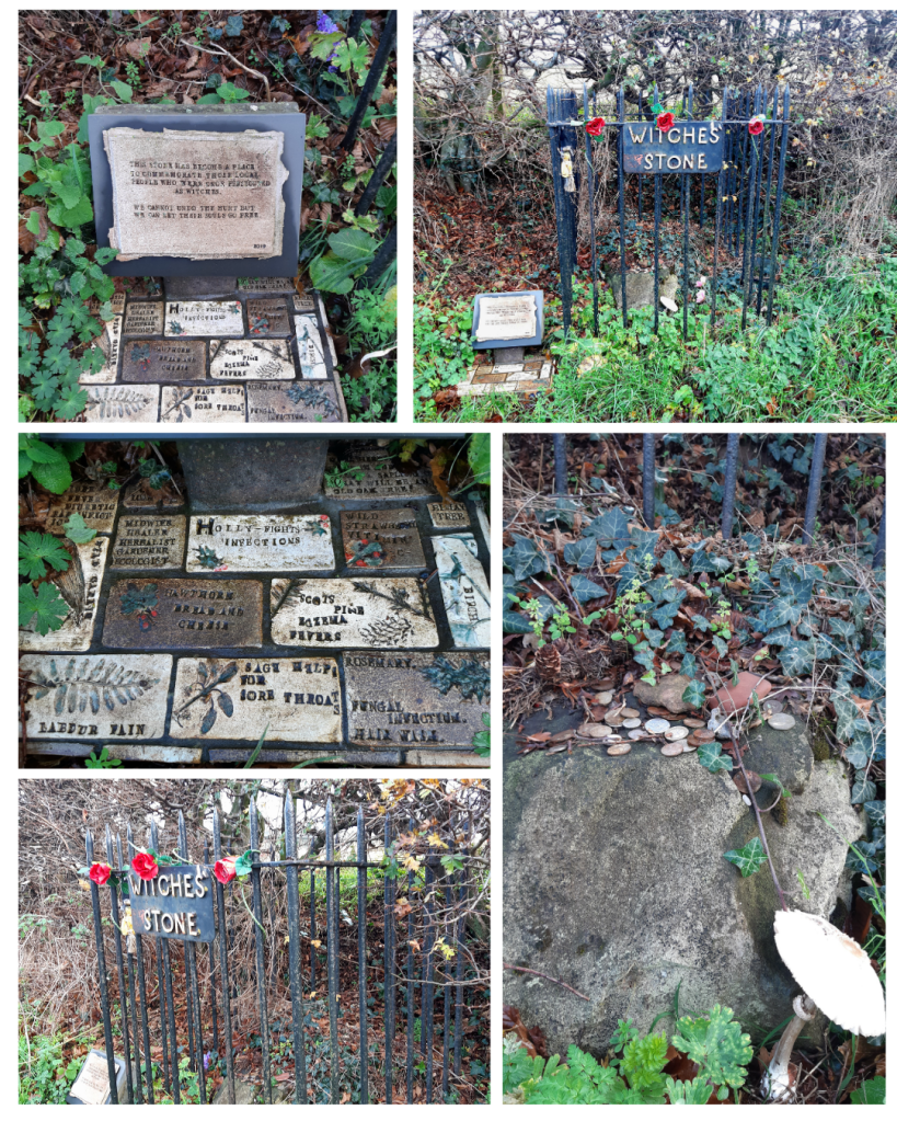
On my first trip away in the van, I drove by here as I’d heard about this stone. Spott is a tiny village only two miles from Dunbar and infamous as the place where the last witch trials and executions were held during the early 18th century. The stone here is a memorial to the burning of a witch in the South of Scotland, Marion Lillie, the Ringwoody Witch. Under the Birley Tree which stood nearby, the local Birley Court was held and sentenced Marion to death. This was in fact just a sham court set up by local Kirk Elders to deal with ‘problematic’ people within their farming community.
Marion had previously been accused of bewitching in 1698 but was never convicted however in 1704 she appeared before the court again, accused of so frightening a pregnant woman that she had a miscarriage. This time Marion was found guilty and in 1705, she was taken to the top of Spott Loan and burned to death as a witch. According to the Spott Kirk Session minutes of the time, ‘Many witches were burnt on Spott Loan’, on 11 February, 1705, un-named but apparently 13 of them in all, the size of a witches coven. These could well have been Marion’s accusers who she perhaps named while being ‘coerced’ during her trial.
This Witches Stone and the plaque which sits by it, now honours Marion Lillie and all those others who lost their lives during the Witch Hunt madness of the 17th & 18th centuries.
The plaque bears a dedication by local poet, Ruth Gilchrist, and reads: ‘This stone has become a place to commemorate those local people who were once persecuted as witches. We cannot undo the hurt but we can let their souls go free.’
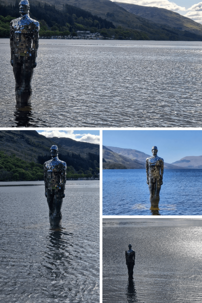
Made from over 800 hand-cut pieces of marine grade mirrored stainless steel, STILL was created by artist, Rob Mulholland. This solitary figure of the ‘mirror man’ as he is also known, stands partially submerged at the St Fillans end of the Loch. At 2.75m / 9ft tall, STILL is witness to the ever changing environment of this area, reflecting the surrounding landscape, sky and water.
Eight years since its removal in 2017, this enigmatic statue has returned to Loch Earn. The community here initiated a fundraising campaign to purchase, restore and reinstate this now beloved artwork. It certainly attracts lots of sightseers. I used to stop by with visitors to see this glimmering man of the Loch and he’s once again back on my list of points of interest.
The artist has said – “The figure is purposefully passive, reflecting the awe and power of nature, and yet can be interpreted as standing stoically – symbolising the human struggle to interact with nature”
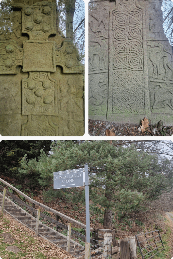
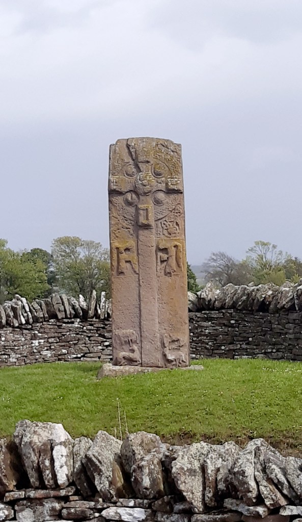
I’d heard about this magnificent stone so finally took the time to stop off to search for it while heading to the Cairngorms. Once you get into Pitlochry it’s actually quite well signposted however there isn’t really much parking nearby so I left the van in town and Millie and I enjoyed a stroll (for the most part) out past the caravan park and along the road to get there. It’s quite a narrow road without pavement and the drivers of a couple of Range Rovers that passed me seemed to think they were in a formula 1 race so Millie and I were forced into the ditch a couple of times. Do take care.
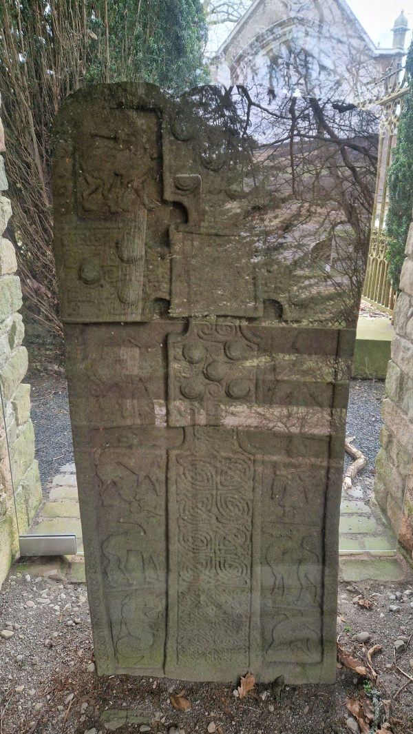
The Dunfallandy Stone is an elaborately carved Class II Pictish stone which is more than 1200 years old. To protect it from the elements, it has been enclosed in a shelter but disappointingly, reflections on the glass make it difficult to see and photograph. Non reflective glass would certainly have been a better option here.
Reminiscent of intricately decorated Pictish jewellery, this cross-slab once marked a place of prayer and is set in its original location, prominently on a mound known to have been topped by a chapel, where it would have been seen by all that passed by. The relief carvings show the sophistication of Pictish culture, mixing influences from across the British Isles and Europe with local traditions and belief. Typically, the body of the Cross is decorated with the familiar intricate Pictish knotwork.
It’s thought that stones such as this one were once coloured, using mineral pigments such as yellow ochre, red lead and green verdigris, emulating the style of metalwork and religious manuscripts of the time. The images on the front depict Pictish monsters (considered agents of God’s wrath), a stag, Jonah being swallowed by a whale and angels. On the reverse side, depictions are of enthroned bishops or saints facing each other, a rider representing perhaps the patron who commissioned the stone then at the bottom are Iron-working tools (tongs, hammer, crucible). There are also several distinctively Pictish symbols on the reverse here, the Pictish monster, double disk and the crescent with v-rod however their true meaning is now lost to us.
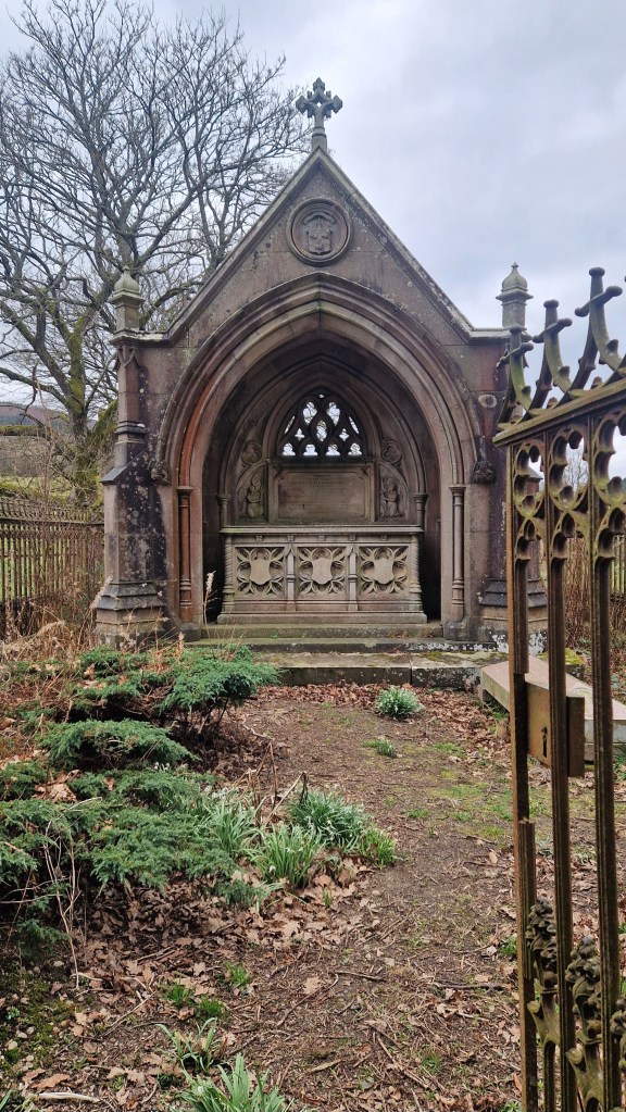
Dunfallandy Stone now shares the mound with burial enclosures surrounded by railings. One of these is the site of the impressive tomb of Lieutenant-General Archibald Fergusson of Dunfallandy who died in 1834. This, I assume would be why the location was referred to as Mausoleum Mound from the 1860’s.
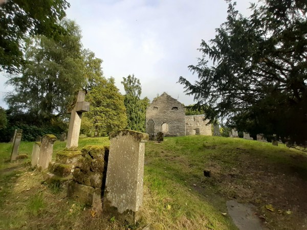
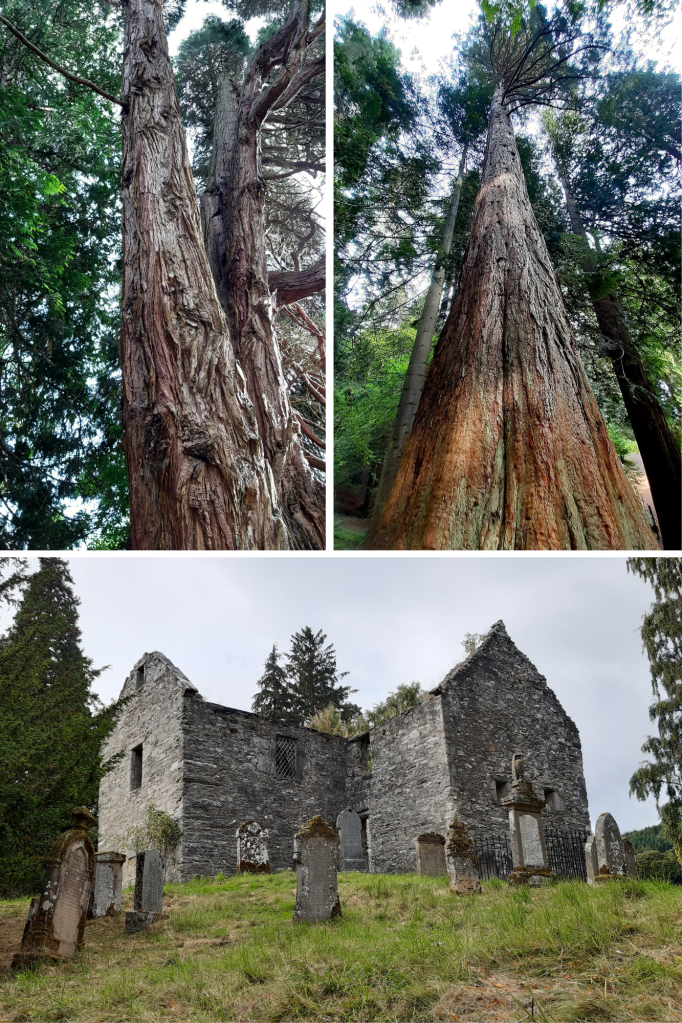
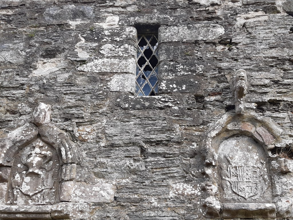
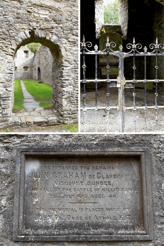
Reaching this 16th century Kirk takes in a lovely walk northward past Blair Castle, through ancient and varied woodland, including exotic Cedar and Sequoia trees, to a clearing on a mound. The Kirk lies where once was the village of Old Blair through which the old Perth to Inverness road used to run. The fabric of this existing structure dates back to around 1560 however its origins are rooted in Celtic times, standing on a raised circular mound, built over earlier churches possibly dating as far back as the dark ages.
Surviving records show that in 1275 when Scottish Churches were required to finance the crusades, St Brides made payments of 32 shillings which was a significant amount in those times. In 1475 Angus Og, the son of John MacDonald II, Lord of the Isles, attacked Blair Castle. The Earl and Countess of Atholl took refuge in the Kirk but were taken prisoner by Angus who sacked and damaged the building. While sailing back to Islay, Angus’ ship was nearly lost in a violent storm and this was interpreted as retribution for what he’d done to the Kirk. It’s told that he immediately returned to Blair Atholl where he paid for repairs to St Bride’s to try to make amends with God for his actions.
The Coat of Arms of the 4th Earl of Atholl and his 2nd wife were mounted on the outside of the Kirk in 1579.
On 27 July 1689, John Graham of Claverhouse 1st Viscount Dundee (known as ‘Bonnie Dundee’) led his Jacobean army against General Hugh McKay’s Government forces at the Battle of Killiecrankie. Victory was on the the Jacobites side that day, however, amongst the many casualties Dundee himself was mortally wounded. Three days after his death his body was carried here to St Bride’s where he was buried in the vault beneath the South Aisle Mausoleum. Sadly, the vault was broken into in the 1790’s and Dundee’s armour was looted and sold as scrap. The breastplate is the only item remaining and is now on display in Blair Castle.
In 1824, the village of Blair Atholl built its own Church so St Bride’s gradually fell into disrepair. The 6th Duke of Atholl was buried here in 1864 then also his wife Countess Anne in 1897. The remains of other family members were reinterred to the West of the Kirk from and earlier family cemetery in 1954.
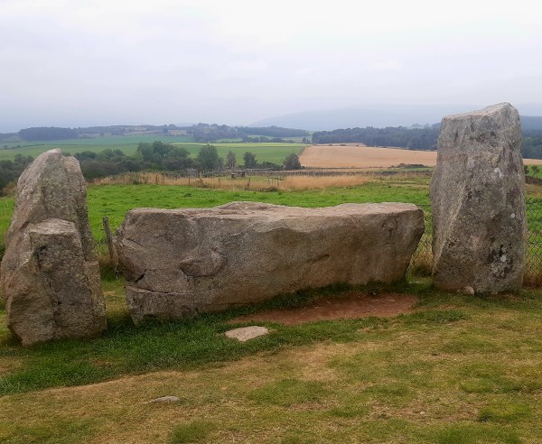
I happened upon this stone circle when I’d come to find nearby Culsh Earth House. Thought to have been built around 5,000 years ago, this is one of several stone circles unique to the north-east of Scotland as it has a recumbent stone. Framed by the recumbent stone the stones flanking either side, the focus of this circle seems to have been Lochnagar, the prominent mountain 20 miles(32km) south-west of here. The Neolithic people who built this circle would have used it to mark the movement of the Moon throughout the year. They undoubtedly linked the landscape and the stars with their spiritual life and would have revered this site as a place of worship. Set upon this wee hill at the centre of these flatlands known as ‘the Howe’, it’s likely that other communities and their stone circles would also have been visible from here.
The centre of this particular circle, surrounded by kerb stones, is known to have been used for cremation pyres. A mound of charcoal, burnt soil and bone was excavated from the centre here in the 1990’s.
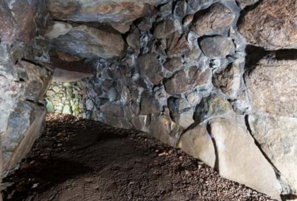
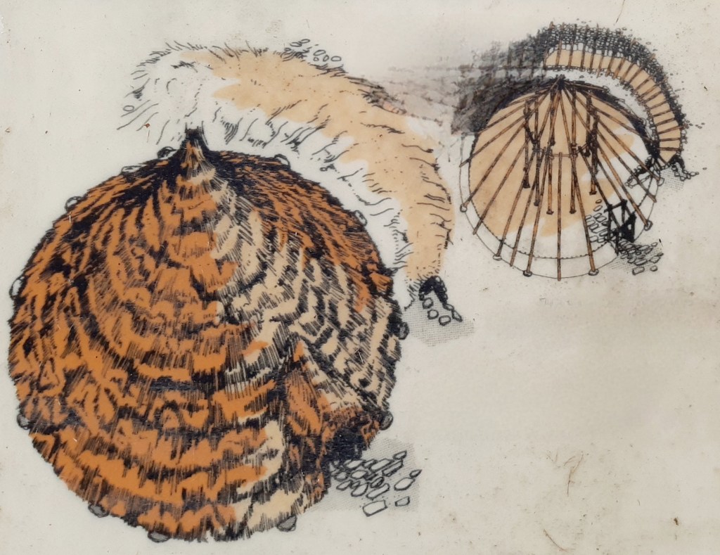
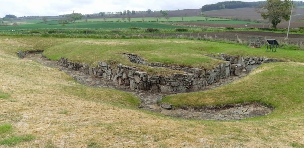
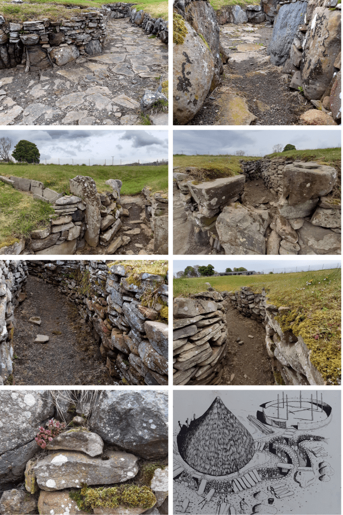
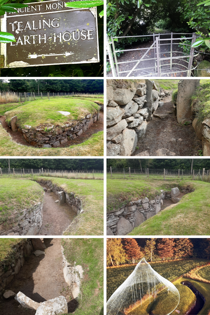
Built about 2,000 years ago, and despite its name, it was not a dwelling, but a 15m stone-lined, underground passage. This Iron Age larder is one of the most complete examples of its kind.
Culsh earth house survives as it was over 2,000 years ago and is one of only a few souterrains in Scotland that can safely be accessed. We don’t know what it was used for – perhaps a storage space, potentially a hiding place, or as two cup-marked stones inside may indicate it may have had some ritual significance. From the outside this souterrain appears to be just a bump in the ground therefore it would not have attracted any attention, It could, however, be entered both from within the round-house built above it and from the concealed outside entrance.
Check out other examples of Scottish souterrains such as those at – Tealing, Ardestie and Carlungie.
At about 40m long, Carlungie Earth House is one of the largest and most complex examples of its kind in Scotland. It was accidentally discovered during ploughing in 1949 and subsequent excavations during the following two years revealed a further eight associated stone dwellings at ground level.
Earth houses, or souterrains as they are also known, were once thought to have been defensive refuges but it’s now considered that they were in fact cellars, as their cool environment would have made them suitable for storing grain, dairy products and meat. These stone-lined underground passages typically date to the Iron Age and have been found along much of eastern Scotland, as well as in Ireland, Cornwall and Brittany. Just a few miles away can be found Ardestie and Tealing ‘earth houses’ and farther north Culsh Earth House just outside Tarland, Aberdeenshire.
It’s amazing the things you come across by chance. I was driving north to Aberdeen when I noticed the signpost for this place, so intrigued, I stopped by to check it out….and what a fantastic find!
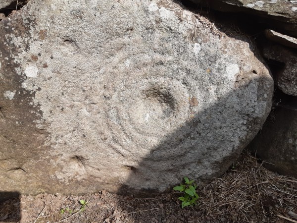
This isn’t actually an ‘earth house’ but an Iron-Age souterrain, a subterranean passage that was originally roofed over with stone slabs. A small room at the end of the chamber here had been created by a pair of huge, up-right slabs. It was discovered in 1871 while a local farmer was ploughing the field here. Souterrains can be found around Scotland’s eastern coast and built around 2,500 years ago, they would have been part of farming settlements made up of clusters of timber roundhouses. Souterrains seem to have been accessed from within a roundhouse built above, providing a cool dark place, most probably used for storing food. They would, however, have been vulnerable to dampness and vermin. They could also have been used as places of refuge if the settlement was under attack. As you can see from the stone-walling, this was skilfully built and may have incorporated a symbolic function. Here at Tealing, pre-historic rock art is carved into one of the huge stones by its entrance. The cup and ring marked stone perhaps represents the sun, the portal to a spirit world, even life itself, or life beyond this realm – eternity.
Excavation at Tealing found animal bones, shards of pottery, broken grinding stones for wheat and fragments of Roman glassware, the latter, suggesting trade routes with distant places. It could also mean this souterrain might still have been in use when the Romans passed through here. Only a few miles East of Tealing a further two Souterrains can be found – Ardestie & Carlungie while another, Culsh Earth House can be found near Tarland in Aberdeenshire.
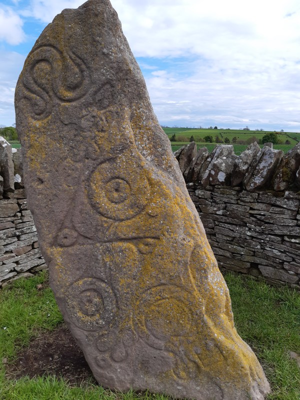
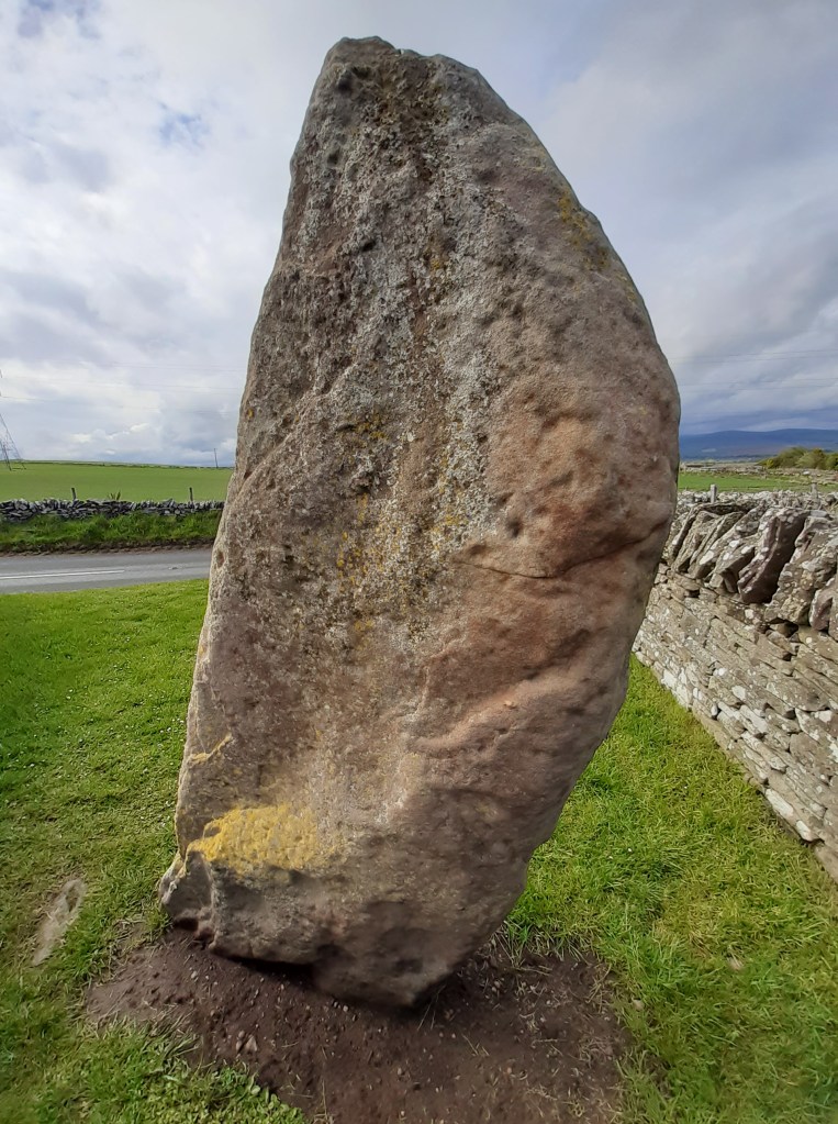
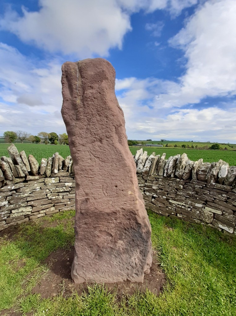
I was excited to come here on this wet and incredibly windy day to encounter a trio of remarkable remnants from our ancient past. AND what a way to begin my journey into Scotland’s pre-history! The Picts ruled much of Scotland during the Dark Ages, had a strong and distinct culture yet little is known of these warring and artistic people. Along the roadside in the village of Aberlermno are three magnificent Pictish stones bearing symbols from three graphic styles as their society evolved from Pagan to Christian worship.
The Serpent Stone – cup marks on the left side of this stone suggest that it was most probably a neolithic standing stone, reused by the Picts. This is a Class I stone, standing nearly 2m tall with carvings deeply incised and still clearly visible.
Class I stones – are natural rocks or boulders bearing incised Pictish symbols dating from the early bronze age. They bear no Christian images therefore likely carved before the arrival of St Columba and adoption of Christianity into Pictish culture.
This stone’s markings show a serpent above a double-disc and z-rod then a mirror and comb.
Serpent – throughout the World snakes have been associated with magic, death and rebirth, sex and healing.
Double Disk – perhaps represents two worlds: the here-and-now and the otherworld, life and death. Its has also been suggested that it signifies the marriage of two families. Z-Rod – this could represent someone whose spear was broken – dead – or who was a breaker of spears – a great warrior
Mirror & Comb – although on some stones the mirror is shown alone it is frequently thought to represent a woman. In the ancient world it has been used elsewhere as a symbol of the mother Goddess. Mirrors and combs also have magical connotations, appearing in folklore as enchanted objects
Whatever the meaning behind the symbols on this wonderful stone, they had a clear significance for the people who made them. The incisions are carbon dated at around 1500 years ago, elements of a lost hieroglyphical system used by the Picts for up to four centuries. They could represent a person of status within their community, mark a tribal location or make known tribal allegiance.
The Crescent Stone – only faint traces of a crescent marking and mirror remain on this Picitsh standing stone but nevertheless it still stands impressively alongside its neighbouring monoliths.
Crescent – having lunar associations, this could also represent the firmament. Often crossed with a v-rod (broken arrow), it’s one of the most common Pictish symbols.
Over these many centuries, such ancient monuments have eroded so that their stories are now completely lost to the wind and rain.
The Roadside Cross – standing in its original socket for over 1200 years, this stone is a Class II stone and testament to flourishing Christianity which had turned the Picts away from their Pagan religion within a mere 200 years of introduction. This impressive cross-slab was a declaration to the Glory of God.
Class II stones – these are shaped stones, carved in relief and almost always cross-slabs with Christian imagery and some traditional Pictish symbols.
The front of this stone has been deciphered as follows: Within a massive wheelhead cross there are Five circular bosses on the cross – possibly representing the wounds of Christ. Mourning Angels – holding gospel books.
The rear side: the top displays a Pictish symbol, the V-Rod – possibly the rising and setting of the sun/moon, then, below it there’s a Double Disk and Z-Rod – more elabourate than on the Serpent stone. A ceremonial hunt – with trumpeters below prominent Pictish symbols. David saving his flock from a lion – perhaps representing Christ the saviour. A centaur gathering medicinal plants – representing Christ the healer
These stones truly are incredible and although sitting by the roadside, each has been situated sympathetically in a small walled area to allow them to be viewed up-close. Grab your raincoat and go…!
As I wandered into the grove beyond Dunino church, sunlight danced through the leaves of the trees surrounding Dunino Den, obscuring my vision. With a sudden fluttering of birds around me, I felt that there was indeed a supernatural atmosphere about this place. It’s said to be haunted by fairies, steeped in Celtic legend and a site of pagan worship that continues to attract pilgrims today. The fabled ‘Altar Stone’ sits up high, overlooking a burn running through the narrow gully below. A small, circular well worn into the rock here is rumoured to have once been used by Druids in their rituals of human sacrifice. Near the well, is a carved footprint, suggesting this was once a place of great significance. Carved footprints were used in Neolithic times, during inauguration rituals where our ancient chieftains would place a foot in such grooves and swear oaths to protect their people and lands. This would suggest that kings from our pre-history might once have been crowned here.
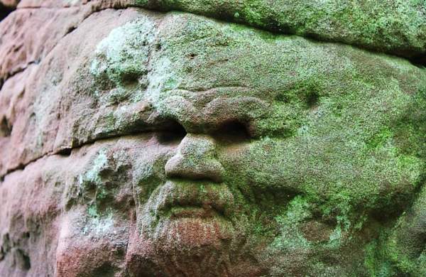
Steps lead down into the Den, to a Wheelhead Cross, ancient symbols and a mysterious face all carved in to the rock. Here, modern day worshippers now leave offerings, believing this place to be a portal to the otherworld. Ribbons flutter from the trees, messages for loved ones, since departed, are stuffed into cracks in the rock and coins left in crevices. Beware! It’s said that removing anything from this place will bring bad luck.
Legend tells of a visitor who came to Dunino Church and having followed the path through the woods to the altar stone, he saw an enchanting hamlet on the other side of the gully. The cottages were thatched and swathed in rambling roses. An old man in knee breeches and a woman in a long gown, stood at the entrance to one of the houses while a blacksmith leant on his hammer outside his workshop. A year later, the visitor returned, this time with a companion to whom he had recounted his story. They arrived at the Den to find the cottages gone and nothing but trees on the other side. It is said that a collection of cottages and a smithy once existed on the land there, but they had been demolished long, long ago….
“Come Faeries, take me out of this dull world, for I would ride with you upon the wind and dance upon the mountains like a flame!” – W B Yeats