Culsh Earth House, Tarland – Aberdeenshire

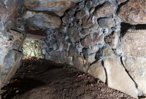
Built about 2,000 years ago, and despite its name, it was not a dwelling, but a 15m stone-lined, underground passage. This Iron Age larder is one of the most complete examples of its kind.

Culsh earth house survives as it was over 2,000 years ago and is one of only a few souterrains in Scotland  that can safely be accessed. We don’t know what it was used for – perhaps a storage space, potentially a hiding place, or as two cup-marked stones inside may indicate it may have had some ritual significance. From the outside this souterrain appears to be just a bump in the ground therefore it would not have attracted any attention, It could, however, be entered both from within the round-house built above it and from the concealed outside entrance.

Check out other examples of Scottish souterrains such as those at – Tealing, Ardestie and Carlungie.

First Detailed Map of Scotland

This outstanding map shows Scotland as an inviting and wealthy Country with great cities, walled towns, majestic castles and grand churches. Presented to King Henry VI of England in 1457 by chronicler, John Hardyng, it was done so as an enticement for the King to invade Scotland.

Hardyng had originally been sent as a spy on a secret mission to Scotland by Henry V (1413-1422) who intended to invade. However, Henry V died so the map became part of Hardyngs first chronicle, ‘A History of England and its Neighbours’. Hardyng suggested a route England’s army could take to invade Scotland.

The Map was being displayed at Wardlaw Museum, St Andrews, while on loan from the British Library, so I took the opportunity to pop by to see it. Being a fan of using maps to find my way around rather than relying on GPS, I was intrigued to see this. It’s not everyday you can have a close up look at something that’s almost 800 years old!

Blog at WordPress.com.

Up ↑